The Old Road That Followed the Easiest Ground
Learn how to read an old road through passes, valley floors, and gentle slopes, and see why its route bends where the land grows difficult.
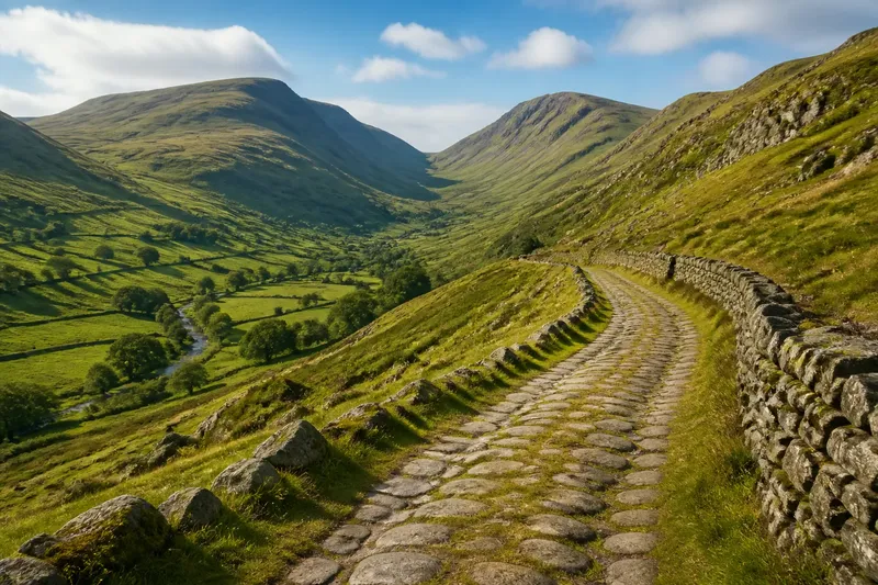
Why does an old road bend around a hill instead of taking the shortest line across it? The answer is often visible in the terrain: the route sought a pass, a valley floor, or a slope gentle enough to cross with the people, animals, and loads it carried. Reading those choices helps explain how neighboring places became connected, even when the road’s present-day path is faint or divided by newer construction.
Why follow easier ground?
A route across difficult land asks for more effort than one that uses natural openings. A steep climb slows a loaded cart; a narrow ravine may leave little room to pass; a wet hollow can turn into a persistent obstacle. A road that takes a longer curve may therefore be easier to use than a direct line over a ridge.
“Easiest” does not mean flat, effortless, or free of hazards. It means the route makes practical use of the ground available: a lower crossing, a broader valley, a manageable gradient, or a gap between high points. The best path may still climb, but it tends to do so where the land gives travelers a workable approach.
That logic can be useful when looking at a map. Notice where the road bends, narrows, or changes direction, then compare those places with the surrounding slopes and ridges. A bend near a pass may reveal a more plausible crossing than a straight line drawn between two towns.
How does a pass shape a road?
A pass is a relatively low route through higher ground. Roads often approach one from the side with the gentlest climb, cross near the lower gap, then descend along terrain that offers a usable way onward. The resulting line may look indirect on a regional map, but it can be a coherent passage through a barrier.
Look for a saddle between higher ridges: the land dips between two raised areas, creating a natural opening. A road may curve toward that dip rather than aim at the highest point nearby. On a topographic map, contour lines that bunch tightly indicate steeper slopes, while more widely spaced lines suggest a gentler rise; the pass itself can be a place where the surrounding contours form a lower notch.
The approach matters as much as the gap. A low pass can still be awkward if a road reaches it by a sharp, steep climb. A route’s full shape may show a gradual ascent on one side and a different descent on the other, reflecting the terrain on each approach rather than a single uniform crossing.
What does a valley floor tell you?
A road that runs along a valley floor is using a long, relatively low corridor between higher slopes. The valley can guide a route across a broad area, linking settlements that face the same passage through the surrounding uplands. The road may follow the valley’s curves instead of crossing the hills that frame it.
Not every valley floor is an easy route. A narrow gorge can leave little room, while a broad valley may offer more space for a road to bend or run beside a stream. In some places the route keeps to a terrace above the lowest ground rather than following the valley bottom itself. That small shift can help explain why a road appears to track the valley but not the watercourse.
Pay attention to changes in the valley’s width and direction. A road may turn toward a broader section, avoid a tight bend in the land, or leave the valley to cross a lower spur. Those shifts can show where one natural corridor ends and another begins.
Why choose a gentler slope?
A gentler slope reduces the strain of climbing and descending, particularly for older forms of travel that relied on walking, pack animals, or wheeled carts. A road can gain height gradually by following a hillside contour, turning back through a series of bends, or approaching a ridge from a less abrupt side.
On a map, a road that makes a broad curve across a hillside may be gaining elevation without pointing directly uphill. Compare the road’s line with contour spacing: closely packed contours mark steeper ground, and a route that crosses many of them at once may face a sharp climb. A route that curves across them can gain height more gradually, though the map alone cannot tell you every detail of the surface.
Say you are tracing an old road between a market town and a neighboring valley. Imagine its line leaves the direct route, follows a broad hillside, and reaches a saddle before descending toward the next settlement. That shape suggests the road used a gradual approach and a lower crossing; the visible bends would be the clue, not proof of who built it or exactly when it carried traffic.
How can you read an old road?
Start by looking at the route as a whole, then inspect the places where it changes direction. A bend may reflect terrain, but it can also mark a settlement, a bridge, a property boundary, or a later alteration. The surrounding land helps you decide which explanation fits, but the route’s shape is only one piece of evidence.
- Find the high ground. Identify ridges and hilltops on a topographic map, then check whether the road avoids the steepest crossings.
- Look for a pass. Follow the road toward a lower gap between ridges and compare the approach on both sides.
- Trace the valley. See whether the route follows a broad low corridor, shifts onto a terrace, or leaves the valley at a narrower section.
- Compare slope patterns. Notice where contour lines bunch together and whether the road bends to avoid crossing the steepest ground directly.
- Check nearby crossings. A bridge, ford, or narrowing in a valley may help explain why the route takes one side rather than another.
- Separate old and new lines. Modern roads may straighten, widen, or bypass earlier routes, so a present-day road does not always preserve the older path.
These are reading clues, not a recipe for identifying every road’s origin. A map can suggest why a route fits the land, while the road’s age and original purpose may remain uncertain without local records or field evidence. What is not worth the effort is insisting that every curve has a single terrain-based explanation: roads can change as communities and travel needs change.
What can maps reveal?
A topographic map is especially useful because it shows relief as well as roads. Contour lines help you see where a climb steepens, where a ridge lowers, and how a valley turns. A shaded relief map can make broad slopes easier to recognize, while an aerial image may show a surviving track or an old roadbed that is hard to distinguish on a general map.
Compare maps carefully, but do not assume that a road’s appearance is identical across them. A regional map may simplify bends and omit minor tracks; a detailed map may show lanes, paths, and local features. Where available, historical maps can help you spot a former alignment, while current maps can show where later roads have replaced or crossed it.
Ground conditions are not fully captured by the shape of a map. Seasonal water, soil, vegetation, and local building all affect how a route can be used. Terrain offers a strong way to interpret a road’s broad direction, but it does not supply every detail of its past.
Which questions help?
Does the shortest route follow the easiest ground?
Not necessarily. A direct line can cross steep slopes or a high ridge, while a longer route may use a pass or a gradual hillside approach. The road’s bends often make more sense when you compare its length with the effort of crossing the land.
Why does an old road avoid a ridge?
A ridge can be steep, exposed, or difficult to cross, so a route may seek a lower saddle or follow the ridge’s side. The map’s contour lines can show whether the road seems to approach a lower opening rather than climb over the highest ground.
Can a valley road run above the valley floor?
Yes. A route may follow a terrace or hillside above the lowest ground, especially where the valley bottom is narrow or difficult to traverse. Its overall alignment can still be guided by the valley even if it does not sit beside the stream.
Does a winding road prove it is old?
No. Curves can result from terrain, later road design, property lines, or other local constraints. A winding alignment may be consistent with an older route, but it is not enough by itself to establish the road’s age or history.
What the route connects
When a road uses a pass or a valley, it connects more than two points on a map. It links places that share a practical corridor through surrounding terrain, and it may shape which neighboring settlements are easiest to reach from one another. The same ridge that separates nearby communities can make a particular pass a shared gateway.
That is why the shape of an old road can say something about regional identity without explaining it all. The road records a relationship with the land: where movement was possible, where it was costly, and which openings helped one place meet the next. To read the route well, follow the ground as carefully as the line.
When you next trace an old road, mark its highest approach, its likely crossing, and the corridor it follows afterward. Those three points can give you a useful terrain-based reading before you turn to questions about names, dates, or ownership.